 |
Outdoors in Utah climbing
skiing
|
|
| ||||
|
OutdoorsIn Utah.com |
Nine Mile
Canyon
A drive though Nine Mile Canyon
is like stepping back in history. If
you stand still you can almost hear the hooves of the Indian ponies clattering on the
rock. This canyon is not unlike the
canyons of Southern Utah, red rock is the dominant color.
The treasure of Nine Mile Canyon is not the geological scenery, although
that isn’t bad. No, the treasure
here are the petroglyphs and remnants of the Fremont Indians.
This area contains the highest concentration of petroglyphs I’ve ever
seen. If you have a good eye you
can view practically thousands of petroglyphs.
It wouldn’t be a bad idea to bring a pair of binoculars to view some of
the distant petroglyphs on private property.
What these drawings mean I can
hardly imagine. Some people think
they know, they post papers and books attempting to explain what someone in the
past was thinking. I’m not sure
what any of them mean, I suppose we’ll never truly know.
I do know that life back in the day wasn’t all work.
These people obviously had free time, and felt the human urge to express
themselves.
Nine Mile Canyon is accessed from
Wellington, Utah. From Salt Lake
City drive down I-15 to Spanish Fork, at Spanish Fork head East on Highway 6. Be careful on this drive, this is the most dangerous highway
in Utah. Continue up and over
Soldier Summit downwards to Price. Continue
through Price and stay on 6 through Wellington. At the far end of town you will see a gas station/subway on
the left, turn into this station and fuel up.
It probably wouldn’t be a bad idea to pick up some water as well.
As you pull into the gas station
reset your odometer. Once you are
fueled and watered up start driving down the road adjacent to the station.
For about 12.5 miles you’ll traverse over desert plateau, brown and
gray are the dominant colors. The
occasional wildflower breaks up the scheme, adding its splash of color.
After 12.5 miles the paved road disappears, from now on travel is over
dirt and rock.
After 20.9 miles you will cross a
bridge over the Minnie Maude Creek. Soon
after this will be a BLM sign proclaiming you are entering Nine Mile Canyon,
this also explains some of the history of the area.
22.5 miles you will come across the first sign of old time life in the Canyon, the fallen down remains of an old homestead are evident. This area is all private property and one must merely drive on. 23.3 miles into the journey
you'll come across Nine Mile Ranch. This attraction features a store and
campground. I noticed the campsites were 10 bucks a night. If I was
camping in the area I'd probably hit the BLM land at the beginning or end.
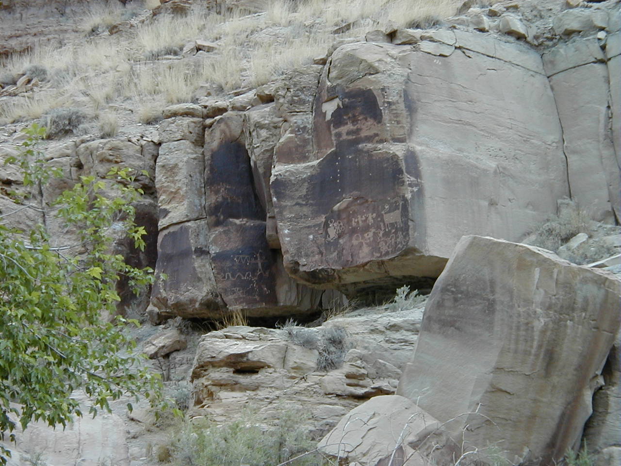
When your odometer reaches 25.8 miles look for a pull-out on the right side of the road, on the opposite side is a rock wall. Get out of the car and walk up to the formation, notice the petroglyphs adorning the lower wall. These drawings are evident everywhere along the wall, then notice the ones up about 20 feet. Access to the upper panel can be had by walking to the left along the cliff and scrambling up. Please don’t touch any of these drawings, the environment is removing these treasures fast enough without our help. At approximately 26.7 miles you
will come across the Cottonwood Glen Picnic Area. This is a nice place to
stop and dawdle a bit. Featuring canopied picnic areas and clean bathrooms
this is a nice spot for lunch.
The next site is located at 29.0
miles an old Fremont granary is visible on the hillside with binoculars. Park along side the road and look off to your left, look up
the hill to the only cliff. Look at
the base of the largest crack on this cliff, a stacked stone structure is
clearly visible.
At 29.9 miles you will come across the remains of a small town. This is the remants of Harper, a once sheep ranch and stage coach stop. Most of this land is now private property, fences keep anyone from exploring. A small panel is visible at 30.1 miles, the usual weird drawings. Keep your eye's open, you'll see many petroglyphs thoughout this stretch. Around 31.3 miles you'll notice a rock balanced on the cliff above the road. Just after you drive around this rock stop the vehicle. Get out and look around, many interesting drawings are nearby. Try to figure out what these early artists were trying to convey? At 32.8 miles you will find another ancient billboard. The designs on this wall are quite strange, what influenced these drawings?
The next must see panel is located at 34.2 miles. This panel is easily
found, three cottonwood
trees directly next to the road are the stopping point. Stop and look to
your left, the panels are evident on the hillside. A petroglyph of a snake
is most evident, this design is viewable with the naked eye. Most of the
other carvings will need binoculars to see, the land around is strictly private
property. 37.6 miles you will encounter a fork in the road, take the right fork into Cottonwood Canyon. This canyon once again is a challenge to find the pictures. Drive slowly, many can be found once you get used to seeing them. After 43.0 miles on the odometer one will find an open area featuring a bathroom. Once you get out of the car take a look around. On your left will be a corral, look around the fence. The cliffs have afforded the local artisans to show their wares
There is much to see in Nine Mile Canyon, keep your eyes open and see for yourself. Please refrain from the urge to carve your own name into the sandstone. Although I understand the need to add to the historical significance for future generations to do so in view of the road is in bad taste. To truly see this canyon you need to get out of your car. Don't just drive down the road and point at the sites. Get out of the damned auto, walk around. Take in the simple beauty of the canyon, flowers are hard to see from the interior of a car. Near Roosevelt I'd recommend staying in the vehicle, speed through this area as fast as you can. Use tunnel vision to see only the road. Pay no mind to the dotting of the land by oil wells, forget you saw the black plastic hosing wandering seemingly aimless through the area. Instead try and remember what it looked like in the way back. Enjoy your time in the outdoors, BobMc
|
Outdoors in Utah | 6875 South Kiesta | West Jordan |
UT | 84084 | 801-982-7834
Copyright, 2000-2002, Bob McMann Website Design and Marketing by Effective Results Contact Webmaster |