Camping: Nebo Loop
On-Line Reservations Now Available!
 The Nebo Loop is one of Utah’s most scenic byways. The road winds along the Eastern side of the majestic Mt. Nebo. Mt. Nebo tops out at 11,928 feet making it the highest peak in the Wasatch range. The road runs between
the towns of Payson and Nephi, covering about 43 miles between them.
The Nebo Loop is one of Utah’s most scenic byways. The road winds along the Eastern side of the majestic Mt. Nebo. Mt. Nebo tops out at 11,928 feet making it the highest peak in the Wasatch range. The road runs between
the towns of Payson and Nephi, covering about 43 miles between them.
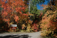
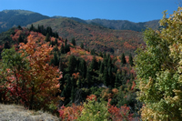 Springtime mountain flowers and autumn colors make this road a feast for the
eyes throughout the spring, summer and fall. The road begins at about 4400
feet and climbs to almost 9300 feet. The Nebo loop is not plowed in the
winter months, it opens mid-spring and closes with the first snowfall.
Springtime mountain flowers and autumn colors make this road a feast for the
eyes throughout the spring, summer and fall. The road begins at about 4400
feet and climbs to almost 9300 feet. The Nebo loop is not plowed in the
winter months, it opens mid-spring and closes with the first snowfall.
To get to the Nebo Loop take I-15 to exit 250, this exit leads into the
small town of Payson. There are several restaurants and stores in Payson,
this might not be a bad time to eat or pick up a picnic lunch. Follow the
signs through Payson to the Loop. The road follows along Peteetneet Creek
as it climbs upward.
There are many places to camp or picnic along the road. The first place you
will encounter is the Payson Canyon Park, this area is popular with locals
and features plenty of picnic tables and grills.
As the road continues to climb, the next recreation area you encounter will be
the  Maple Lake campground. The turn off to Maple Lake is signed and quite
obvious; drive up the road that ends at Maple Lake. The campground is
nestled in a grove of Aspen trees and in the fall a carpet of colorful leaves
makes the campground seem almost enchanted. The sites are all first come
first served, each site is $8.00 per night.
Maple Lake campground. The turn off to Maple Lake is signed and quite
obvious; drive up the road that ends at Maple Lake. The campground is
nestled in a grove of Aspen trees and in the fall a carpet of colorful leaves
makes the campground seem almost enchanted. The sites are all first come
first served, each site is $8.00 per night.
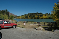 If you continue along the loop the next campground reached will be the
Payson Lakes Campground. This campground has several group areas and three
individual site loops. The campground is situated next to Big East
Reservoir which provides fishing opportunities and a scenic trail along the
shoreline. McClellan Lake is located near the group campsites, Box Lake is
If you continue along the loop the next campground reached will be the
Payson Lakes Campground. This campground has several group areas and three
individual site loops. The campground is situated next to Big East
Reservoir which provides fishing opportunities and a scenic trail along the
shoreline. McClellan Lake is located near the group campsites, Box Lake is  located between the two camping areas. Rainbow and Brook Trout are stocked
in all of these lakes. Powerbait, marshmallows and nightcrawlers are the
usual bait of choice. All the campsites are nicely shaded, well spaced, featuring fire rings and picnic tables. The single sites are all $11.00 each.
located between the two camping areas. Rainbow and Brook Trout are stocked
in all of these lakes. Powerbait, marshmallows and nightcrawlers are the
usual bait of choice. All the campsites are nicely shaded, well spaced, featuring fire rings and picnic tables. The single sites are all $11.00 each.
The Blackhawk Campground is the next campground along the loop. This
 campground is a bit more organized than the preceding ones. There are five
loops, many of the sites are available for reservation. Although the sites all
have picnic tables, fire pits, and nearby bathrooms, there isn’t as much
shade as the two preceding campgrounds. The E-loop is a popular horse
camping area, most all campsites have bars to tie up horses at night.
campground is a bit more organized than the preceding ones. There are five
loops, many of the sites are available for reservation. Although the sites all
have picnic tables, fire pits, and nearby bathrooms, there isn’t as much
shade as the two preceding campgrounds. The E-loop is a popular horse
camping area, most all campsites have bars to tie up horses at night.
After the Blackhawk campground the road continues on climbing past several
fantastic overlook points. Many hiking trails crisscross the area, be sure
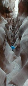
and get out 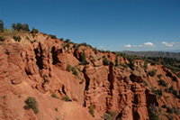 of your car and put your feet to the dirt. The Devil’s Kitchen
is a short stroll down a paved trail, at the end of which is a view of
features eerily similar to Bryce Canyon. Red rock has been eroded into
hoodoos and small pillars just like it’s Southern cousin, albeit on quite a
bit smaller scale.
of your car and put your feet to the dirt. The Devil’s Kitchen
is a short stroll down a paved trail, at the end of which is a view of
features eerily similar to Bryce Canyon. Red rock has been eroded into
hoodoos and small pillars just like it’s Southern cousin, albeit on quite a
bit smaller scale.
Towards the Southern end of the loop the Salt Creek Canyon road branches off
to the right, this road leads up to three very nice campgrounds. The
Ponderosa Campground is the first one along the road, this campground has 22
very nice sites. The campground is situated in a stand of Ponderosa Pines;
plenty of shade is provided by these large trees. Sites 2, 3, 6, 14, 15,
18, and 19 are all located on the  banks of Salt Creek. At night you’ll be
able to be lulled to sleep by the sounds of a babbling brook. Bathrooms
are located near all sites and picnic tables and fire rings are standard at
every site. Each single site is $11.00 per night, no horses are allowed in
the campground. The sites in this campground can be reserved and during the
peak season reservations are highly recommended.
banks of Salt Creek. At night you’ll be
able to be lulled to sleep by the sounds of a babbling brook. Bathrooms
are located near all sites and picnic tables and fire rings are standard at
every site. Each single site is $11.00 per night, no horses are allowed in
the campground. The sites in this campground can be reserved and during the
peak season reservations are highly recommended.
 The Cottonwood campground is up next, this is a rather primitive campground.
There are 16 sites, each well shaded by the large cottonwood trees around,
hence the name. There is only one restroom for the entire campground, but,
near as I can tell the sites are all free.
The Cottonwood campground is up next, this is a rather primitive campground.
There are 16 sites, each well shaded by the large cottonwood trees around,
hence the name. There is only one restroom for the entire campground, but,
near as I can tell the sites are all free.
 The Bear Canyon Campground is located at the end of road, there are three
group areas and several walk-in campsites. The walk-in campsites appear to
be free as well, although they lie along a rather well traveled hiking
trail. The first walk-in campsite is rather unique in that there are logs
cut to provide natural camping chairs.
The Bear Canyon Campground is located at the end of road, there are three
group areas and several walk-in campsites. The walk-in campsites appear to
be free as well, although they lie along a rather well traveled hiking
trail. The first walk-in campsite is rather unique in that there are logs
cut to provide natural camping chairs.
The road continues on past the Salt Creek Canyon road to end up on highway
132, make a right (Westerly) on this road and it will take you into Nephi
and an entrance onto I-15.
If you have never driven, hiked, or camped on the Nebo Loop, I’d highly
recommend it. Payson is only about 40 minutes from the Salt Lake City
valley, it doesn’t take that long to reach one of the treasures of the
state.
Campgrounds
Payson Lakes
Blackhawk
Ponderosa
Bear Canyon
Shopping
Books
| |
Utah
Atlas and Gazetteer
by DeLorme (Editor)
Book Description
Rely on the Utah Atlas & Gazetteer for the utmost in
trip planning and
backcountry access. Contains
topographic maps with unbeatable
detail, plus gazetteer
information on great places to go and things to do.
Scale equals 1:250,000 or 1"=4 miles. Contour Interval is
300'. Each
page
covers 37 miles... Read
more |
Utah's National Parks: Hiking, Camping, and Vacationing in Utah's Canyon Country: Zion, Bryce, Capitol Reef, Arches, Canyonlands
Utah
Camping: The Complete Guide to more than 400 Campgrounds
(Foghorn Outdoors)
Camping Utah (Camping)
Utah Camping Guide : The essential handbook for
...
Backcountry
Adventures: Utah: The Ultimate Guide to the Utah Backcountry for Anyone
With a Sport Utility Vehicle
Backcountry
Moab - Where The Tours Don't Go
Exploring
Canyonlands and Arches National Parks
Hiking
and Exploring Utah's San Rafael Swell
Utah
Underground: Guide to Real Fun
Travel
Smart: Utah
Hidden
Salt Lake City and Beyond: Including Park City, Deer Valley,
Alta and Snowbird
Get the 2005 Trailer Life Directory for 50% off the cover!
Return
to Camping Index