Camping:
Kane Creek Road
Camping:
Kane Creek Road
 At
the McDonalds in town head West on Kane Creek Road. Reset your
odometer as you make the turn.
At
the McDonalds in town head West on Kane Creek Road. Reset your
odometer as you make the turn.
2.6 miles from McDonalds is the starting
point for the Moab Rim Trail. The Moab Rim Trail is rated 4+ and
is not for the faint of heart. There are several obstacles that
could be catastrophic if things went bad. 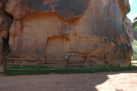
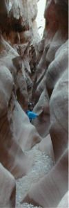
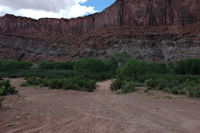
Moonflower Canyon is located 3 miles from the turn-off.
There is an interesting petroglyph panel located at the
beginning of the canyon. Quite a few modern idiots have logged
their own name on the panel, please refrain from following their
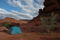
examples. Moonflower Canyon features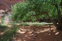 eight walk in campsites, these sites are $5.00 per vehicle per
night. Two vehicles, two tents and six people are permitted per
site. The canyon is rather sandy and is a bit cooler than the
surrounding desert, this makes for a very nice place to camp.
Restrooms and a dumpster are on site, the dumpster is the only
one in all of Kane Creek and is for all of the BLM campgrounds
in canyon.
eight walk in campsites, these sites are $5.00 per vehicle per
night. Two vehicles, two tents and six people are permitted per
site. The canyon is rather sandy and is a bit cooler than the
surrounding desert, this makes for a very nice place to camp.
Restrooms and a dumpster are on site, the dumpster is the only
one in all of Kane Creek and is for all of the BLM campgrounds
in canyon.
 4.1
miles from the turn-off is the Kane Springs Campground. This
campground is privately owned. The campground is very close to
the shores of the Colorado River, it runs for about a half mile
along the road. The sites are a bit pricey at $16.35 per night,
there is a $5.00 per site charge for extra vehicles, and a $5.00
charge for any ATV or vehicle trailers. Water and showers are
available at the main campground, showers are $3.00 apiece.
4.1
miles from the turn-off is the Kane Springs Campground. This
campground is privately owned. The campground is very close to
the shores of the Colorado River, it runs for about a half mile
along the road. The sites are a bit pricey at $16.35 per night,
there is a $5.00 per site charge for extra vehicles, and a $5.00
charge for any ATV or vehicle trailers. Water and showers are
available at the main campground, showers are $3.00 apiece. 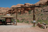
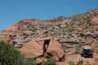
At 4.5 miles is the trailhead for
Pritchett Canyon. The trailhead is on private property and a
small fee is required to enter. Pritchett is one of the toughest
trails in the Moab area and is rated 4+.
At 4.6 miles the pavement ends, reset your
odometer to zero at this point. 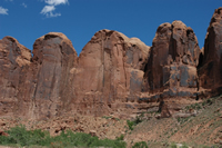
.7 miles from the end of the pavement you
will come to the Amasa Back trailhead parking lot. From the
parking lot you have a spectacular view of the Kane Creek
Tombstones. Occasionally on summer days you can see people base
jumping from the top of the tallest Tombstone.
1.2 miles from the end of the pavement is the trailhead for the
Amasa Back Trail. This is a popular mountain biking trail and is
known as Cliffhanger for
the 4x4 crowd. Cliffhanger is rated a 4, probably a bit too
tough for stock vehicles without a locking differential.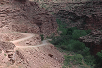
At 2.0 miles from the pavement the road
switches back down into the bottom of the Canyon. .2 miles
further is the Spring Site campground. This campground features
four sites at $5.00 per vehicle per night. The campground is
very shady and is located near the Kane Springs. There are pit
toilets, but no water.
3.1 miles from the end of the pavement is
Hunter Canyon. This is another BLM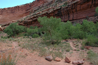 campground featuring pit toilets and costing $5.00 per vehicle
per night. There are nine campsites, four are walk-in sites and
five are car camping sites. This is also a riparian area with
plenty of shade and a cool stream. About a half mile up-canyon
from the campground you’ll come across Hunter Arch, this makes
for a nice little hike from your campsite. Kane Creek flows over
the road just past the campground. The stream isn’t very deep
and even passenger cars can navigate the crossing.
campground featuring pit toilets and costing $5.00 per vehicle
per night. There are nine campsites, four are walk-in sites and
five are car camping sites. This is also a riparian area with
plenty of shade and a cool stream. About a half mile up-canyon
from the campground you’ll come across Hunter Arch, this makes
for a nice little hike from your campsite. Kane Creek flows over
the road just past the campground. The stream isn’t very deep
and even passenger cars can navigate the crossing.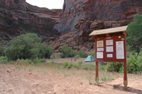
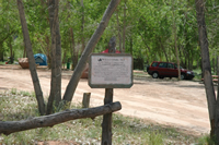
Echo Campground is located 3.3 miles from
the pavement. This is the last of the BLM campgrounds and
features nine campsites and pit toilets. Echo has plenty of
tamarisk and a few cottonwoods to provide shade. It costs the
same $5.00 per vehicle as the other campgrounds.
Soon after Echo you will go over a
cow-catcher, after the cow-catcher the camping is not organized.
Camping can be found down many non-descript trails. If you camp
out here please bring a self-contained toilet as there are no
bathroom facilities. If you don’t bring a toilet at least
carry a trowel and dig a hole to conceal your waste. Burn or
carry out any toilet paper you use. The desert is a much more
fragile place than it appears, please do your part to keep it
clean for all of us.
 I’m
not going to list every place to camp, but the following places
are some of the more used sites.
I’m
not going to list every place to camp, but the following places
are some of the more used sites.
At 4.0 miles from the pavement there is a
turn-off to the right, there are several places to camp and the
area has a bit of shade. If you are going to have a fire be sure
and choose someplace that already has a fire ring made.
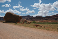 4.7
miles from the pavement there is a huge boulder on the right
side of the road, there is a turn off to a few campsites just
after the boulder. There is a large cottonwood tree to provide a
little shade for one of the campsites.
4.7
miles from the pavement there is a huge boulder on the right
side of the road, there is a turn off to a few campsites just
after the boulder. There is a large cottonwood tree to provide a
little shade for one of the campsites.
4.8 miles is another pull off with a few
places to camp.
At 5.1 miles there is another dirt road to
the left with some previously camped at spots.
5.3 miles from the pavement is a series of
trails 4 wheelers frequent, there are some sites to camp in. Be
aware you will probably be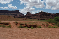 woken up to the sound of an off road vehicle if you camp here.
5.6 miles from the pavement is a pull off
that has two spots to camp. The first is a bit in the open and
can be seen from the road. If you continue past the first spot
you’ll come to another place a bit more secluded.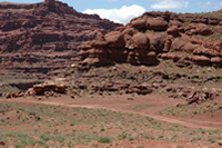
As your odometer clicks to 6.0 you’ll
see a road leading to the right, there are a few spots nestled
in the tamarisk to camp in.
6.3 miles from the pavement you’ll come
across the second stream crossing. This crossing is a bit
deeper than the first one, I’d probably not want to take a
normal passenger car across the stream. There are several roads
leading to the left before and just past the crossing. The trail
after the crossing holds many places to camp, some of these will
be right next to the stream.
 At
6.6 miles you’ll come across a road to the right, this road
leads out to numerous camping spots. The cliff walls and
formations provide shade, dependent on the time of day. About 20
yards past the trail on the right you’ll see a sign pointing
down a trail to the left. This trail is the Kane Creek Canyon
4x4 trail. This trail is rated a 3+ and features plenty of water
crossings. The true difficulties of the trail don’t happen
until the climb back up to highway 191. This climb ascends a
shelf road which quite often will necessitate the use of stacked
rocks to climb up over the steps.
At
6.6 miles you’ll come across a road to the right, this road
leads out to numerous camping spots. The cliff walls and
formations provide shade, dependent on the time of day. About 20
yards past the trail on the right you’ll see a sign pointing
down a trail to the left. This trail is the Kane Creek Canyon
4x4 trail. This trail is rated a 3+ and features plenty of water
crossings. The true difficulties of the trail don’t happen
until the climb back up to highway 191. This climb ascends a
shelf road which quite often will necessitate the use of stacked
rocks to climb up over the steps.
Soon after you pass the entrance to Kane
Creek Canyon the road enters Kane Valley, there aren’t many places to camp until after you pass
over Hurrah Pass. Hurrah Pass is located 9.7 miles from the end
of the pavement. As you start to approach Hurrah Pass the going
gets a bit rougher, this would probably be the place to turn
around the family sedan. From Hurrah Pass on, a high clearance
four-wheel drive vehicle is necessary.
Valley, there aren’t many places to camp until after you pass
over Hurrah Pass. Hurrah Pass is located 9.7 miles from the end
of the pavement. As you start to approach Hurrah Pass the going
gets a bit rougher, this would probably be the place to turn
around the family sedan. From Hurrah Pass on, a high clearance
four-wheel drive vehicle is necessary.
Kane Creek is a fantastic gateway to loads
of hiking, biking, climbing, four-wheeling and camping. Please
clean up after yourselves and keep this area pristine for the
people coming after you.
To read more about the Moab area, click here.
Nearby Areas:
Arches National Park
Canyonlands National Park
Moab
Resources
Book Siteseeing Tours & Other Adventures Here
Maps
Shopping
Books
Get the 2005 Trailer Life Directory for 50% off the cover!
Return
to Camping Index