The
state of Utah’s educational budget is heavily dependent on
mineral and oil rights royalties. The Dutch firm of Andalex was
poised to begin mining on this very land.
They had plans to reap the rewards of the coal-fields in
the Kaiparowits plateau while giving a pittance to the state.
I hate to say this but most Utahn’s would be happy to
see Southern Utah strip-mined to death while they happily pump
out children.
As
you may be able to tell I’m a bit biased in this argument.
I agree with the monument wholeheartedly.
Call me green, call me an environmental whacko,
whatever… I
don’t care. I am
of the crowd that believes we don’t need to use up everything
we have. I’d like
my son’s children to be able to venture out into an unspoiled
environment.
Ok,
enough said. Think
about those first six words of my sermon…
Think of what they mean in the grand scheme…
Sandstone
Sandstone
is the medium Mother Nature chooses to use in Southern Utah.
This material comes in varying hardnesses.
Wind deposited or water deposited is the main difference.
The different formations in the monument are because of
the various types of sandstone.
Each succumbs to the tools of nature differently, hence
the fantastic sights afforded to us.
Wind
This
chisel of nature has reared its head on both sides of the
monuments formation. Much
of the sandstone in this monument was formed by wind blown sand
dunes. This same
force today is working to erase these formations.
Water
Water
is perhaps the most powerful force on the Colorado Plateau.
Rain is rather rare in this environment.
When it does come it falls upon a sea of rock, the water
attempts to find its way to the lowest point.
The action of water upon sandstone is a slow but much
more artistic way to cut stone.
Man has attempted to carve stone, nature has a bit more
gentle touch.
Geologic
Forces
The
Colorado Plateau has been formed by many different types of
sandstone. These
layers have been exposed by various uplifts.
Volcanic activity and plate shifting caused the rivers to
carve the almost surreal landscape we see today.
Time
Time
is a hard to define part of the equation.
Suffice it to say that time is defined in the desert by
how many grains of sand were washed away in the latest flash
flood. Time has
allowed the forces of water and wind to work their magic on the
surrounding countryside.
I
challenge everyone who reads this article to get out and see a
bit of your own local terrain.
Take the time to appreciate what time has created for
you…
The
Monument Itself
The
Grand Staircase-Escalante (from now on known as GSE), is quite
an expansive monument. I
have to keep correcting myself from calling it a Park.
The area of GSE encompasses approximately 1.7 million
acres. That’s a
lot of ground! GSE
is bordered by two national parks (Capitol Reef, and Bryce
Canyon), one national recreation area (Glen Canyon), and one
national forest (Dixie). The
area contained is a wonderland of colors and formations.
The
Grand Staircase rises in a multicolored series of steps towards
the Western border of the monument.
The Eastern section of the monument is comprised of the
Escalante River drainage area.
This is a magical land full of canyons and washes, a
testament to the forces of nature mentioned earlier.
The central portion of the monument is the home of the
Kaiparowits plateau.
Many
of the features of the Monument can be viewed by various
overlooks. Highway
12 and 89 both provide a scenic way to see the Monument by way
of the auto. Highway
12 has been listed as one of the top ten scenic drives in
America. The most
scenic portion of this drive is between the towns of Boulder and
Escalante. The road
climbs, winds and descends its way throughout some of the most
awe-inspiring scenery you’ve ever seen.
The highway lies on the crest of a ridgeline for a while,
1000 foot dropoffs on either side of the road.
If you have the time and are traveling through the area
I’d recommend driving the entire length of HWY 12.
The Northern section of this highway climbs over Boulder
Mountain. This
climb up the mountain allows for some views that are out of this
world. Views of
Capitol Reef National Park and the waterpocket fold are
supplemented by a seemingly endless view of the Southern San
Rafael Swell.
Be
very careful if driving any of the highways around here at
night. Deer are a
plentiful animal, don’t be surprised if you venture upon a
herd crossing the road on a dark night.
Keep an eye out for the glow of their eyes, be diligent
while night driving.
Camping
The
area in the monument seems to be regulated much the same as BLM
land, i.e. there are few regulations on camping.
Backcountry camping is allowed in pretty much all of the
monument, a free permit is available at most trailheads.
There are plenty of car/truck camping sites throughout
the monument. When
I say car/truck camping I mean a spot where it is obvious
another party has camped before.
Some of these sites may be hidden a bit, down a
non-descript two track. I’d
recommend buying the “Utah Atlas & Gazetteer” by Delorme
publishing.
As
I always stress in all my reviews please tread lightly on any
site you choose to camp at.
If you plan on having a campfire please pick a spot that
already has a fire ring, don’t create another scar on the
landscape. While
breaking up your camp pick up every little piece of trash you
have created, and what the heck, pick up anything anyone else
left behind. If at
all possible confine your hiking to established paths or washes.
The desert relies on a protective crust called
cryptobiotic soil. This
crust allows the flowers and other forms of vegetation to
survive. Once
broken the nomadic soil is allowed to migrate.
There
are many places to camp out “Hole in the Rock Road.”
The proximity of this road to the town of Escalante is
convenient. In
Escalante the traveler can fill up on gas and provisions.
The convenience store/gas station nearest to Hole in the
Rock Road has fuel pumps open 24 hours and a water spigot.
The water spigot is actually the biggest draw, if you are
heading into the desert water will become your best friend.
For
the less adventurous camper there are a couple hotels in
Escalante to fill your needs.
This monument is still in its infancy stages, there are
no large tourist portals to serve the average sight-seeing
American.
Hiking
This
monument has some of the best hiking of any Utah parks.
GSE is home to some of the nation's best slot
canyons. My latest
camping trip in the GSE involved hiking three slot canyons. From
one central entrance point
I hiked/scrambled my way through the Dry Fork of Coyote
Gulch, Peekaboo Gulch, and Spooky Gulch.
Each of these slot canyons was worthwhile in their
respective ways.
To
reach the trailhead for these slot canyons one must drive out
“Hole in the Rock Road” for 25.5 miles from its intersection
with HWY 12. After
25.5 miles you will see a sign announcing a road to the left
proclaiming Dry Fork 1.7 miles.
Take a left on the road (I use the term road loosely)
immediately after the sign.
Follow this road out the proclaimed 1.7 miles and park in
the parking lot.
Once
parked fill your pack full of water and strap on a pair of
tennis shoes. I’d
recommend a pair of hiking boots normally, but you’ll be
better off with tennis shoes on this one.
Occasionally on the hike you’re liable to find some
standing water. Being
a day hike there’s no need to lug around in a pair of sodden
hiking boots.
The
hike down into the canyon is marked by a couple signs, follow
the most evident of the paths and you’ll find yourself at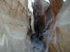 the head of a wash. Once
at the bottom of the wash you’ll notice a narrow canyon
leading off to your left. This
canyon is the Dry Fork of Coyote Gulch.
the head of a wash. Once
at the bottom of the wash you’ll notice a narrow canyon
leading off to your left. This
canyon is the Dry Fork of Coyote Gulch.
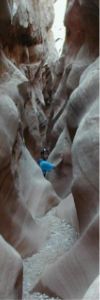
Coyote
Gulch is a relatively straightforward slot canyon.
The going doesn’t get much narrower than four feet
wide, other than a couple steps up boulders the hiking is level.
After about a mile the canyon walls become shorter and
wider, this trail eventually joins Hole in the Rock road.
It’s best to turn around when the canyon widens and
return to your starting point.
 Once
back to where you joined Coyote Gulch continue downstream a
couple hundred yards. Peekaboo
Gulch is a bit harder to find, the entrance is about 15 feet up
a vertical wall. This
wall will be on your left hand side and can be identified by
steps carved into the wall.
Once
back to where you joined Coyote Gulch continue downstream a
couple hundred yards. Peekaboo
Gulch is a bit harder to find, the entrance is about 15 feet up
a vertical wall. This
wall will be on your left hand side and can be identified by
steps carved into the wall.
You
must scramble up the wall using the cut steps, this is rather
easy but can be intimidating to novice hikers.
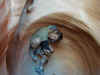
After you negotiate the wall you will pass through pool like depressions,
sometimes you’re liable to find standing water here. Separating
these two pools is a set of arches, this is a great spot to stop
and take a photo.
negotiate the wall you will pass through pool like depressions,
sometimes you’re liable to find standing water here. Separating
these two pools is a set of arches, this is a great spot to stop
and take a photo.
 The going gets weirder as you continue on your way.
The water has carved the sandstone into intricate
passageways. The
canyon eventually becomes shallow enough to where it is possible
to scramble to the plateau.
Before you retrace your path back down again be sure and
look at the canyon you just navigated.
The going gets weirder as you continue on your way.
The water has carved the sandstone into intricate
passageways. The
canyon eventually becomes shallow enough to where it is possible
to scramble to the plateau.
Before you retrace your path back down again be sure and
look at the canyon you just navigated.
After
you have negotiated back down the wall out of Peekaboo continue
hiking downstream. A
couple of turns down Coyote Gulch you’ll come across a cairn
marking a trail rising over a small sandbar.
Make a left here and follow it into Spooky Gulch.
Spooky can also be accessed at it's upper end from Peek-a-boo,
hike cross country from the top of Peek-a-boo Gulch.
Follow the obvious cairns taking care not to get sucked into the
canyon separating the two.
Spooky
is the most narrow slot canyon I have ever been in.
At one spot the canyon narrows to approximately a foot
and a half wide. Spooky
also provides the most physical obstacles of any of the three I
hiked in this area. A
half wide. Spooky
also provides the most physical obstacles of any of the three I
hiked in this area. A
 short distance after the narrowest portion one must chimney up
over a vertical ridge. The
canyon continues on for some time, after a while you’ll reach
the other obstacle. A
stack of boulders provides the excitement of this predicament.
When I went through there were two ways up and around
this obstruction. You
could either chimney up and walk along the top by going left.
Taking the right version would have you climbing up a
face then tunneling under the rock..
short distance after the narrowest portion one must chimney up
over a vertical ridge. The
canyon continues on for some time, after a while you’ll reach
the other obstacle. A
stack of boulders provides the excitement of this predicament.
When I went through there were two ways up and around
this obstruction. You
could either chimney up and walk along the top by going left.
Taking the right version would have you climbing up a
face then tunneling under the rock..
If
one continues hiking down Coyote Gulch further you can hike
Brimstone Gulch as well. Although
I’ve heard Brimstone is the best of the four slot canyons
accessed from here I wasn’t able to hike it.
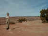
I had an almost eight months pregnant wife back at camp
and a bored three year old.
As it was, it took us about three hours to hike the three
we did and get back to the parking lot.
There
are many backpacking trails traversing this area.
Not all are located off “Hole in the Rock.”
From what I’ve been able to figure out by looking at
the on-line monument boundaries Paria Canyon is located within
the monument. This
canyon is a popular backpacking destination.
One of the alternative paths through this canyon is
Buckskin Gulch, this is the longest slot canyon in the desert
Southwest. Buckskin
is twelve miles long and averages under 15 feet in width.
I’ve never been here yet but hope to take a fall trip
through the gulch.
These
hikes I’ve mentioned are but a few scenic ways to see this
monument. Check
with the ranger station in Escalante for more information.
Conclusion
I
believe this is an integral addition to the federally controlled
lands in the Southern Utah Canyonlands.
People who view this area as “worthless” land should
come out and see what nature’s hand has created. Get out
and see the countryside, see this area before it becomes
overrun.
Return
to Exploring Index


 Exploring:
Grand Staircase Escalante
Exploring:
Grand Staircase Escalante


